Traces of human settlements in Central Africa date back to the very early human history. The skull of the Sahelanthropus tchadensis (5 million years b.C.) was found 2002 in an area North of Lac Tchad. Findings of palaeolithic and neolithic settlements in North Cameroon indicate, that this fertile land in the Lac Tchad bassin has been inhabited for at least 20.000 years.
A detailed description of the history can be found at (LINK). Here we present some of our own impressions and findings:
Prehistory
Little is know yet about the long period of the palaeolithic age, and only a few traces have been discovered yet: On the hill behind the slaughterhous in Maroua, and near Mayo Lidi in the Boubandiddah National Parc there were palaeolithic settlements:
(photo Faustkeil)
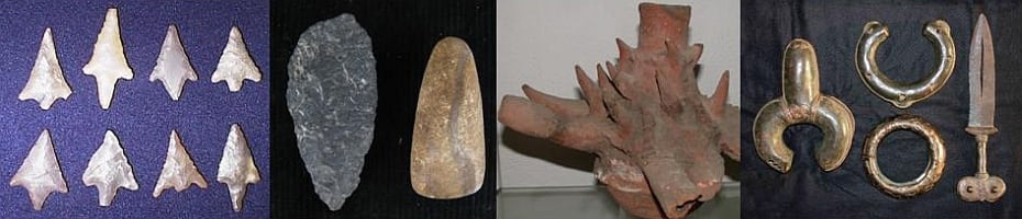
In the neolithicum (8000 -to 2000 b.C.), the sahara was not as hostile as now and flint-stone tools are abundant:

During our chemotheraopy trials (“Macrofil”) on the Ranch Amao near Galim, I found a stone axle right at the corral: (photo stone-axle)
Pre-colonial times
Artefacts from the Nok (Northern Nigeria) and Sao (North-Cameroon and Tchad) cultures are found in the savanna South of Lac Tchad.

ancient pottery from North Cameroon
A magic pottery from North Cameroon. Its many openings let the spirits move in (and out) freely, I have been told.
German colony
In Bouea, where was the German Government stayed until its move to Yaounde, two monuments are particularly interesting:
The Puttkamer ‘castle’ and the Bismark fountain:

Puttkamer castle in Buea

Bismark fountain in Buea (ca. 1930)
Jesko von Puttkamer was accused for his luxurious way of life, and the chancellor von Bismark never was very much in favour of Germany colonialist adventures.
There were vivid discussions in the Deutschen Reichstag in Berlin, for example about the construction of the New Port of Douala in March 1914:

Duala-Hafen – 1914: suggestions for construction No 1

Duala-Hafen – 1914: suggestions for construction No 2
Advantages and disadvantages of the four suggestions were discussed, but only a few months later, the outbreak of WW I abolished all planning. Yet it is interesting to compare these original plans with the nowadays situation.
With view to the endemicity of human onchocerciasis, the first map of the river Moungo near Kumba already shows the same location of villages as nowadays, and the number of inhabitants did not change much until now.

map of Bolo (near Kumba, Moungo river) in 1902
There seems to have been only little growth in the population denisty for almost 100 years. Major events were the settlements of ‘slave villages’, funded by homeless former slaves soon after colonization.
Bolo (Bulu in the map) nowadays (Google Earth, 2011)

Bolo today (Google-Earth, 2011)
Human onchocercasis in Bolo has been described by Duke et al. 1968 and Jacobi et al. 2010.

Bolo-children-Jacobi-Renz-Fig-3
There are still many building from the Germay time to be seen in Douala, Buea, Limbe and other places. German colonial days when the last troops gave up or moved in Equatorial Guinea. In the mountains near Banjo, objects from the last stand of German troops were found:

German objects from the Banjo mountain
German coins, gun bullets, decorative knobs from uniforms and the cover of a sugar box were found in a cave on the mountain, were parts of the Schutztruppe had retired (objects found by Mr. West-Bauer, Ngaoundéré).
French and British mandats of Cameroon
The former German colony was set by the Völkerbund under a British and French mandate. One small part (Yola) went to Nigeria, but the anglophone Western part and the larger French part decided, by public vote, to form the ‘Republic of Cameroon’ in 1961 and, and, after independence, the ‘United Republic of Cameroon’ in 1972.
Recent history
Our own work allowed us to get an impression of the more recent history of a very particular site in the Sudan savanna, the Campement du Syrien on the banc of river Vina du Nord near Sora Mboum. This were we set up our field laboratory to study the Simulium damnosum s.l. populations along the river Vina du Nord.

Campement du Syrien at river Vina du Nord
Entomology laboratory in the boucarou of the Campement in 1988
In 1985 we took over this settlemet of a few houses constructed in ‘semi-dur’ and transformed it into our field base for entomological studies in Vina du Nord river valley, hyperendemic for human onchocerciasis.
The place is called ‘Campement to Syrien’ to remember a Syrien merchant, who settled at this place around the years 1920. He wanted to trade, but finaly was killed during the revolt of the Mboum tribe against the local Foulbe Lamido (Sultan). His grave is still there on a hill close the river. A few laterit stones, laid in form of a cross, which we tried to maintain.

Prehistoric human settlements in the Vina du North valley
The villages, at that time, we located in strategic positions of the top of the hills and mountains. Most of them far away from the river and swamps, and thereby protected from the risc of onchocerciasis, schistosomiasis and malaria. Only when they moved to their new settlements along a new-build road along the river, some of these new settlements came dangerously close to the water.
")
Epidemiology of onchocerciasis along the river Vina du Nord in 1987 (A. Renz)
Leave a Reply
Want to join the discussion?Feel free to contribute!